Special to CosmicTribune.com, September 6, 2023
By Richard Fisher
On Aug. 13 from the Xichang Satellite Launch Center in Sichuan Province, China used a Long March-3B space launch vehicle to loft into geosynchronous orbit (GEO) its first massive LuDiTanCe 04 or Land Exploration-4 01, now the world’s largest synthetic aperture radar (SAR) imaging satellite in GEO.

As it stands, the Land Exploration-4 01 is the world’s largest publicly acknowledged L-Band SAR satellite in geosynchronous orbit with a foldable antenna the size of a football field.
That day state media Global Times reported, “developed by CAST [China Aerospace Science and Technology Corporation] in Beijing, the satellite is tasked with using its synthetic aperture radar to obtain images and data to support disaster prevention and mitigation, ecological monitoring and emergency response efforts. Its users are the Ministry of Emergency Management and the Ministry of Ecology and Environment.”
However, most likely, the main “customer” for the imagery produced by this satellite will be the Strategic Support Force (SSF), which controls China’s satellite fleet for the People’s Liberation Army.
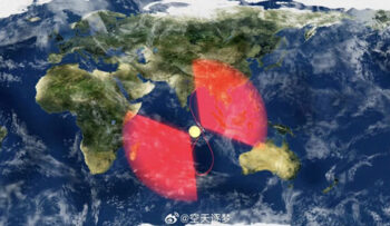
Its GEO orbit means from an altitude of over 35,000 kilometers above the Earth, it will maintain a constant “fixed” position over the Earth to provide near continuous monitoring of areas below, on Earth.
An Aug. 14 article by Andrew Jones in Space News cites a China Aerospace Science and Industry Corporation (CASC) publication from January 2023 noting China will launch a high orbit SAR with a “20 meter” of 65-foot resolution.
This level of resolution is sufficient to track most naval combat ships and large military and civil aircraft, which could help cue targets for other PLA space and ground-based sensors with much higher resolution to assist targeting.
L-Band SAR satellites are also all-weather, they can penetrate cloud cover to find moving targets or can also monitor land and ocean developments to assist resource exploitation.
Full Text . . . . Current Edition . . . . Subscription Information
China lofts world’s largest imaging satellite into geosynchronous orbit added by Cosmic1 on
View all posts by Cosmic1 →
You must be logged in to post a comment Login