Special to CosmicTribune.com, May 13, 2026
By Richard Fisher
An ominous new development emerged earlier this year during the build-up of United States military forces in the Persian Gulf region prior to Feb. 28, 2026 U.S. and Israeli war with Iran:
China exposed that buildup with “commercial” satellite imagery made public on Chinese social media.
At first, it was thought that China was engaging in a psychological warfare tactic by exposing the vulnerability of U.S. air forces as they deployed to bases in Saudi Arabia, Jordan, Israel and the United Arab Emirates, and the vulnerability of U.S. naval forces as they also deployed to the region.
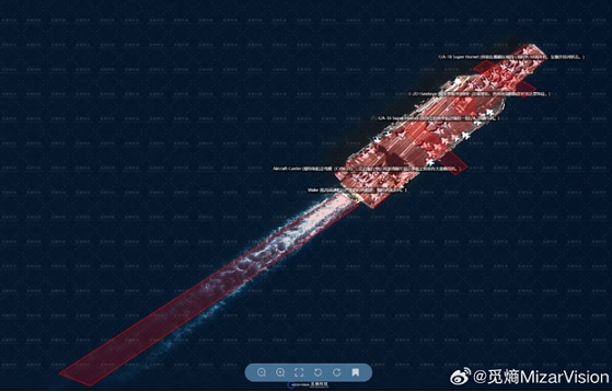
Also for a period, it was thought that somehow the Chinese government was not behind this effort inasmuch as the prominent provider of such satellite images was a “commercial” company called MizarVision that was not necessarily controlled the Chinese government.
But the reality of China’s space information relationship with Iran was revealed in bits.
An analyst named Shivan Mahendrarajah stated on the X platform on Feb. 2, 2026:
“Iran taps into China’s advanced satellite network, which delivers persistent (24/7), all-weather, day-and-night imaging, high-resolution video, SIGINT, and real-time ELINT on US Navy targets. Yaogan ELINT triplets deliver precise global and regional geolocation of ships through triangulation of electronic emissions, while Jilin clusters ensure continuous high-quality visuals. Fusion of Chinese space-based ISR and Iranian missiles creates a real-time kill chain targeting naval traffic in the Persian Gulf, Gulf of Oman, and Arabian Sea.”
That Chinese satellite would be providing targeting data to help Iran find its missile targets, and also providing navigation data to ensure Iran’s missiles hit their targets, became a painful possibility as Iran started its massive missile and drone terror campaign after the start of the war.
Iran has fired nearly 7,000 missiles and drones since the start of the current war, with 551 ballistic missiles and 2,265 drones fired at the United Arab Emirates alone — with the possibility that all of Iran’s missiles have benefited from Chinese surveillance and navigation satellites.
Full Text . . . . Current Edition . . . . Subscription Information
China’s satellite image companies revealed U.S. buildup before start of Iran War added by Cosmic1 on
View all posts by Cosmic1 →
You must be logged in to post a comment Login