Special to CosmicTribune.com, April 10, 2024
By Richard Fisher
Two years into its war against Ukraine, Russia’s military strategy has devolved to one barbaric word: Attrition.
Russian dictator Vladimir Putin has revived historic strategies against Ukraine that worked against Napoleon and then Hitler: Sacrifice as many Russian soldiers as necessary to wear down the defenses of and then kill enough Ukrainians to force concessions that can be turned into future military gains.
It is also the case that Russia’s war of attrition increasingly is displacing traditional platforms like strike fighters, tanks and even classic infantry with a plethora of precision guided and unmanned weapons: Precision-guided artillery, precision guided long range rockets and missiles, and precision guided and even self-guided drones.
But Russia’s new war of attrition, just like Ukraine’s revolution in defense reliant on the same new technologies, are all enabled by one new element without which they cannot function or prevail: Information.
Drone warfare is especially intimate, increasingly targeting individual vehicles, tanks or even individual solders, so it is necessary for the attack drone operator to have immediate knowledge of their potential targets as the drone has a limited range or endurance due to its size or battery power.
This “intimate” information can be obtained at a “retail” level by employing hundreds or thousands of close-flying surveillance drones, which is both personnel and resource intensive, or it can be obtained at a “wholesale” level from space.
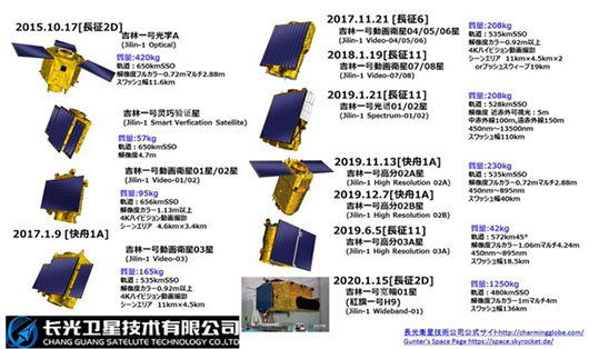
Or the modern term of art is “geospatial intelligence,” in which new intelligence units are able to combine data from electro-optical, radar and multispectral surveillance satellites, electronic intelligence satellites, communications surveillance satellites, and then multiple sources of Earth borne drone-surveillance, plus electronic and signals intelligence.
This data can then be analyzed or processed increasingly with artificial intelligence algorithms, to generate intimate information on the disposition of an enemy that is literally hiding in buildings, behind walls or in a dugout foxhole
Full Text . . . . Current Edition . . . . Subscription Information
U.S. warns China’s geospatial intelligence support for Russia lowers space warfare threshold added by Cosmic1 on
View all posts by Cosmic1 →
You must be logged in to post a comment Login